By using this website, you agree to our use of cookies (needed to provide our website’s features) and our Terms of Use.
By: Andrew Forrest - June 2025
Looking for the best compass to navigate your outdoor adventures? In this guide, we explore the top compasses of 2026 to help you make an informed choice, ensuring you stay on track in any terrain.
For walkers, hikers, orienteers and outdoor adventurers, a compass is an indispensable tool. It enables navigation in various weather conditions, even when electronic devices malfunction. A compass helps align your map with north and is essential for taking bearings in low visibility. Unlike GPS devices or smartphones, a compass doesn't require a battery or satellite signal to function.
This page contains affiliate links. If you buy products or services via these links, we may earn a small commission at no cost to you. If you are thinking of buying, please use our links, as it helps support our website and YouTube channel.
The choice of a compass can significantly impact the navigation experience. From the best overall compass to budget-friendly options and gifts, this section reviews our pick of the top models available, ensuring you find the perfect tool for all your walks and adventures here in the UK. A compass is an essential piece of kit for any hiker.
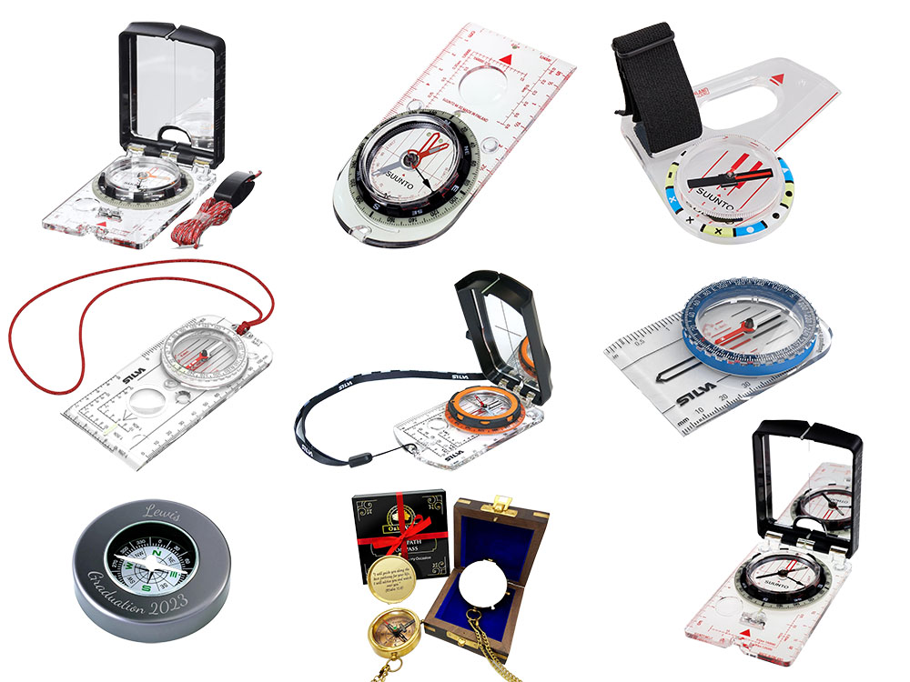
Navigating the great British outdoors requires a reliable compass that suits your needs, whether you're a Duke of Edinburgh's Award participant or a seasoned hillwalker. Below, we've compared nine top-rated compasses - from budget-friendly options to feature-packed models with mirrors and global capabilities - all popular among UK hikers and orienteers. We'll examine what each compass is, who it's best suited for, and what makes it special.
| Compass | Main use | Size | Weight | Key features |
| Suunto M-3 | General hiking & walking | 61 × 120 × 14 mm | 46 g | Adjustable declination, luminous bezel, silicone feet, magnifier, OS map scales |
| Silva Expedition 4 | General hiking & walking | 125 × 60 × 10 mm | 38 g | Full Romer scales, luminous markings, long baseplate, durable design |
| Silva Starter 1-2-3 | Beginner navigation & training | 51 × 76 × 10 mm | 26 g | Simple baseplate, clear markings, thumb curve, basic map scales |
| Suunto MC-2 | Precision navigation & mountaineering | 65 × 101 × 18 mm | 74 g | Mirror sighting, clinometer, luminous dial, adjustable declination |
| Silva Ranger 2.0 | Technical hiking & mountain use | 65 × 109 × 15 mm | 88 g | Mirror, clinometer, slope card, DryFlex bezel, measuring lanyard |
| Suunto MC-2 Global | International travel & global hiking | 65 × 101 × 18 mm | 75 g | Global needle, mirror, clinometer, adjustable declination |
| Suunto AIM-6 NH | Competitive orienteering | 80 × 70 × 11 mm | 27 g | Thumb mount, ultra-stable needle, fast settling, sector indicators |
| God’s Path Compass | Inspirational gift | 50 mm diameter | 115 g | Brass build, engraved scripture, decorative case, symbolic use |
| Personalised Chrome Compass | Custom gift | 57 mm diameter | 73 g | Chrome finish, custom engraving, gift tin, basic compass functionality |
The Suunto M-3 is a high-quality baseplate compass that many hikers consider to be the gold standard for general navigation. It is a simple flat compass with a clear baseplate that you lay on your map to take bearings. Suunto, a Finnish brand, designed the M-3 to be robust yet user-friendly, making it ideal for everything from lowland walks to serious hillwalking.

 |
 |

Specs & features:
Pros:
Cons:
Description:
The M-3 has a clear, crisp dial and an easy-grip bezel. It even glows in the dark - perfect for UK winter navigation when night falls early, as the 360° dial offers excellent luminescence for low-light use. The NH version is designed for the northern hemisphere.
Who is it good for?
Just about anyone who needs a reliable compass. The Suunto M-3 suits Duke of Edinburgh's Award hikers, Mountain Leader trainees, and weekend
ramblers alike. It's particularly beneficial if you're prepared to advance from a basic beginner compass to one that offers greater precision.
The M-3 features an adjustable declination setting, which allows you to account for the difference between magnetic north and true north. This is particularly useful for precise work, although in the UK, the magnetic declination is currently negligible.
This compass is also balanced for the northern hemisphere, making it ideal for use in the UK and Europe. It features a fast-settling needle that quickly stabilises, ensuring you aren't left tapping the compass while waiting for it to stop wobbling. The build quality is top-notch - Suunto still manufactures its compasses in Finland, and the M-3 feels slightly more premium than some rival models, with robust, durable plastics that can withstand being knocked about in your rucksack.
What makes it special?
The Suunto M-3 strikes a perfect balance between advanced features and affordability. It offers features typically found on higher-end compasses,
such as grippy silicone feet that keep it stable on the map, and the adjustable declination screw for those who travel abroad or seek precise
calibration. Nevertheless, it remains lightweight at 46g and slim.
The bezel is exceptionally easy to turn, even while wearing gloves, and features a smooth incremental scale of 2° for precision. The compass includes standard map scales (1:25k and 1:50k for Ordnance Survey maps, plus 1:20k and 1:24k for international maps), enabling you to measure distances on your map.
A couple of things it lacks, which I find useful, are the Romer grid lines and the 1:40k scale used on Harvey maps, as used in the Original Mountain Marathon (OMM). It's not for everyone, but I prefer a longer baseplate, which helps when lining up two points on a map. That's not for everyone, though, as some people prefer the shorter ones as they fit better in the hand.
Overall, the M-3's accuracy, durability, and features have earned it a reputation as one of the best compasses for hikers who want to navigate with confidence.
The Silva Expedition 4 is a true classic - if you learned navigation through Scouts or DofE, chances are you've used one of these. It's a full-size baseplate compass that has been trusted for decades, often recommended as the go-to compass for UK hill walking. In fact, it's DofE Recommended Kit, meaning the Duke of Edinburgh's Award scheme officially suggests it for participants.

|
|
 |
|
 |
|


Specs & features:
Pros:
Cons:
Description:
The Expedition 4 has everything you need in a traditional compass: a clear baseplate with multiple map scales, a rotating bezel, luminous points for night navigation, and even a magnifying glass for reading map details. It's built from robust plastic and designed to withstand the typically tough treatment it might get on hikes (drops, knocks and all).
Who is it good for?
This compass is perfect for hikers and trekkers of all levels, especially those on a budget who still want quality. Because it's so affordable
(usually around £30) and reliable, it's popular with Duke of Edinburgh's Award students, Scout groups, and Mountain Leader trainees alike.
It's an 'expert' level compass that's still easy for beginners to pick up - the Silva 1-2-3 guides you through taking bearings step by step. The baseplate is long and features Romer scales (these are tiny grid reference rulers) for the main map scales, which makes plotting your coordinates on an Ordnance Survey map straightforward.
A big plus for me is that it has the full set of Romer markings for 1:25k, 1:50k and 1:40k - Silva designed this model with all three, so it's ideal if you use OS Explorer (1:25k), Landranger (1:50k), or Harvey maps (1:40k). Not every compass includes the 1:40k scale, so this is a big plus for UK walkers who use Harvey maps and for those partaking in the OMM.
What makes it special?
The Expedition 4's strength is in its simplicity and completeness. It doesn't have fancy extras like a mirror or global needle, but it nails the
fundamentals. The capsule is filled with liquid to steady the needle, which is a high-quality Swedish steel needle on a jewel bearing - very
smooth and precise.
It has a fixed declination scale inside the capsule (a small gauge showing degrees of difference) to help you account for magnetic variation. However, note that you can't mechanically set declination on this model; instead, you'd adjust it manually when taking bearings, which is generally acceptable for most UK walkers.
The bezel rotates 360° with 2° graduations and features a grippy edge that's easy to turn, even with gloves or cold fingers. At night, you get luminous markers - the north arrow, orienting markings, and direction-of-travel arrow all glow after being 'charged' with a light source, providing about 6 hours of glow.
Another handy feature: little silicon rubber feet on the bottom keep the compass from sliding on your map. At just 36 g weight, it's impressively light, yet the baseplate is long (12.5 cm), which makes it easier to take accurate bearings by lining up with map features.
This is the compass I've used for many years in over 20 mountain marathons (KIMMs, OMMs, SLMMs and more), and it never let me down.
The Silva Starter 1-2-3 is an entry-level compass that's ideal for beginners or as a spare to include in your kit. Consider it as a 'training compass' - it's simple, lightweight, and effective without any frills. The Starter 1-2-3 features a compact baseplate (smaller than the Expedition 4) that is designed to fit comfortably in smaller hands, making it popular among schools and youth groups introducing children to navigation.

|
|
|
|

Specs & features:
Pros:
Cons:
Description:
Despite its lower price, Silva hasn't compromised on clarity: the baseplate features ample transparent area and a prominent red direction arrow, making it easy to see your map beneath and follow the arrow when taking a bearing.
Who is it good for?
The Silva Starter 1-2-3 is ideal for new navigators, such as young Scouts, Duke of Edinburgh's Bronze participants, or anyone learning map reading
for the first time. If you're teaching a family member or a classroom of children how to orient a map and walk on a bearing, this compass is
perfect.
It also serves as a handy backup compass for experienced hikers seeking a lightweight spare, as it weighs only 26 grams. Hillwalkers who typically rely on GPS but desire a just-in-case analogue compass often carry the Starter, as it is nearly unnoticeable in their pack.
However, if you're venturing into challenging terrain or conducting a navigation assessment, you would likely wish to upgrade to a more advanced model once you've grasped the basics. The Starter 1-2-3 is valued by scouts, schools, and leisure outdoor navigators as a dependable companion for all basic-level outdoor adventures.
What makes it special?
Its simplicity, comfort, and value are apparent. The Silva Starter 1-2-3 reduces navigation to its essentials: it features a rotating bezel, a
clear baseplate with rulers in both millimetres and inches, and two common map scales (1:50,000 and 1:25,000) printed along the edges for
measuring distances.
A small detachable lanyard is included, which is handy to prevent kids (or anyone else) from dropping it in the mud. One thoughtful design tweak - the baseplate has a slight up-curve at the back end, enabling it to sit more comfortably in the palm (your thumb rests in the curve). It's not something you'll find on fancy compasses, but it helps youngsters hold it correctly.
The needle is the same high-quality Swedish steel type Silva uses in higher models, so it reliably points north, and the capsule is liquid-filled for quick settling. You even get a tiny declination scale inside the capsule as a learning aid (though again, it's not adjustable).
While it doesn't have a magnifier or luminous markers, in daylight it's very easy to read with a clear font on the dial and markings. All in all, the Starter 1-2-3 provides all the basic functions you need to learn navigation without overwhelming you with features, and at a low cost.
If you're seeking pinpoint accuracy and enhanced functionality, the Suunto MC-2 mirror compass is an excellent choice. This professional-grade compass features a sighting mirror, a flip-up lid with a mirror inside, allowing you to aim at distant landmarks (such as a building or mountain summit) while simultaneously reading the compass dial for a very precise bearing.

|
|

Specs & features:
Pros:
Cons:
Description:
The MC-2 is often the compass of choice for mountaineers, search-and-rescue teams, and serious navigators who require that level of precision. Suunto has equipped this model with a wealth of features, including a clinometer for measuring slope angles (useful for assessing avalanche risk, determining the steepness of a route, or pinpointing your location), an adjustable declination mechanism, luminous markings, and even a small magnifying lens on the baseplate. Essentially, the MC-2 possesses all the features a navigator could desire, in a robust package.
Who is it good for?
The Suunto MC-2 is ideal for experienced hikers, navigators, and outdoor professionals - anyone who traverses challenging terrain or simply
enjoys having the best tools. For instance, if you're hillwalking or climbing in Scotland during winter, the clinometer on the MC-2 can assist
you in gauging slope angles to stay safe from avalanches.
If you participate in mountain marathons or navigation events, the sighting mirror enables you to take bearings with greater accuracy (sighting compasses like this can narrow the error down to ~1° if used carefully).
The MC-2 is also an excellent choice for international travellers. While the standard version is optimised for the northern hemisphere, Suunto offers a Global variant (discussed later) that operates effectively worldwide. Many Duke of Edinburgh's Award supervisors and Mountain Leaders consider the MC-2 their trusted compass due to its reliability in virtually any scenario.
However, even if you're just a casual hiker, you might find value in the MC-2 for its durability and capability for any journey - it's like having a professional-grade option. Keep in mind, though, that it is bulkier and heavier than simpler compasses, and it often comes at a higher price.
What makes it special?
The MC-2 is akin to the Swiss Army knife of compasses: it incorporates multiple additional tools. The standout feature is the mirror with
sighting hole and notch. It is used by opening the mirror to approximately a 45° angle, allowing you to align the sighting notch with a
distant feature while simultaneously viewing the reflection of the compass dial, which facilitates highly accurate bearing readings.
This is invaluable for long-distance navigation, such as pinpointing which ridge to aim for across a valley. The mirror also serves as an emergency signalling mirror if required. Then there's the adjustable declination correction: a small screw allows you to set the compass for the local magnetic declination so you don't have to remember to add or subtract it each time (in the UK, declination is now only a couple of degrees at most, but in other parts of the world, it can be significant).
The MC-2's declination adjuster is easy to use - it features a tiny screwdriver concealed within the lanyard's snap-lock (a clever Suunto touch), and you simply turn a screw to set the offset on an internal scale. The compass capsule is of high grade, featuring a jewel bearing and a steel needle for accuracy, and is liquid-filled for enhanced stability. Suunto even engineered a ~20° tilt margin on the needle, meaning the needle won't stick or drag if the compass isn't perfectly level - a useful feature when navigating rough terrain.
Additional features comprise glowing luminescent markings (allowing the dial, orienting arrow, etc., to illuminate in low light), UTM roamer scales on the baseplate (designed for map grids, typically 1:24k USGS scales on select models, along with cm/inch rulers), and a detachable lanyard with a wrist-lock for enhanced security. Furthermore, it includes a built-in magnifier for reading small map text or symbols.
The entire unit folds in half (with the mirror closed) to safeguard the compass face and enhance its compactness. Weighing 75 g, it's not the lightest option available, but given its functionality, it remains a sensible choice. Suunto emphasises quality - the MC-2 is manufactured in Finland and includes a lifetime warranty. In summary, this compass offers precise navigation in demanding conditions, crafted to ensure you stay on course confidently when exploring the unknown.
The Silva Ranger 2.0 is another excellent mirror compass, offering a feature set comparable to the Suunto MC-2, but with Silva's take on the design. It's called the 'Ranger' because it evolved from Silva's classic Ranger series - essentially, it's a modern upgrade that includes a mirror and other advanced features.

|
|


Specs & features:
Pros:
Cons:
Description:
The Ranger 2.0 boasts a sleek black and orange design and comes with a few innovative extras, notably a slope angle card and a distance-measuring lanyard. Similar to the Suunto, it features adjustable declination, a clinometer, and luminous markings. Built to last, it is renowned for its exceptional durability, with a thick acrylic baseplate that feels solid in the hand. If you're searching for a top-notch compass and prefer Silva's layout or pricing, the Ranger 2.0 presents a compelling option.
Who is it good for?
The Silva Ranger 2.0 is designed for more experienced users - hikers engaged in complex navigation, mountaineers, advanced-level orienteers, and
outdoor instructors. It's ideal for anyone tackling steep ground navigation or winter expeditions, thanks to the clinometer and slope card (the
slope card is a small insert that helps you quickly estimate slope steepness and even plan extra distance for uphill routes).
Like the MC-2, it's somewhat of a luxury for the average lowland dog walker, but if you regularly hike off-trail in poor visibility or instruct navigation, you'll appreciate its features. Many users who favour Silva compasses (perhaps because that's what they learned on) will find the Ranger 2.0 familiar yet enhanced.
Note that Silva also offers an Expedition S (a higher-end sibling with similar features, plus a split mirror); nonetheless, the Ranger 2.0 often strikes the right balance in terms of price and features, making it our runner-up mirror compass. It's calibrated for the northern hemisphere, making it suitable for navigation in the UK and Europe.
What makes it special?
The Silva Ranger 2.0 boasts a few unique features. My favourite is the DryFlex™ grip - the bezel is coated with a rubbery DryFlex™
material, providing a secure grip when turning the dial, even when it's wet or when you're wearing gloves. I found it very smooth to operate,
regardless of what I had on my hands... what a shame the Expedition 4 doesn't have this bezel.
Secondly, the slope card: it's essentially a small card that you can use alongside the compass to determine the slope angle from a map's contour spacing or to verify the clinometer reading. This is excellent for winter safety, such as avoiding avalanche-prone slopes, or simply understanding how much additional effort a climb might require.
Third, the distance lanyard: the Ranger 2.0's lanyard isn't just a string - it's printed with scales (1:25k, 1:50k, 1:24k, 1:62.5k) so you can measure distances on your map by using it as a tiny ruler. I found this flexible map-measuring trick is really handy when planning routes, or quickly estimating how far any quick diversions from my planned routes are.
Of course, the Ranger 2.0 has all the standard features too: an adjustable declination screw (with a tiny screwdriver cleverly hidden in the lanyard's buckle - don't lose it!), a sighting mirror with a sighting hole and an alignment crosshair for extra accuracy, and a built-in clinometer (you tilt the compass and read the incline scale, or simply use the printed slope card). By tilting the mirror to a 45-degree angle, you can verify your direction by observing the bezel in the mirror while aligning with the intended path.
The baseplate has three Romer scales (1:25k, 1:50k, 1:24k) printed on it, which cover the main maps plus the 1:24k scale (commonly used on US topographic maps). The dial is marked in 2° and 20° increments with a bold, easy-to-see font. The cardinal directions imprinted on the orange rubber are not as easy to read.
At night, the Ranger 2.0 also features luminous markings. Charge them during the day or with a headtorch, and you're good for some night navigation. The body is extremely sturdy - as noted, the baseplate is thick, and the whole compass has a rugged feel.
One more small plus: when the mirror is closed, the Ranger 2.0's lid almost fully covers the baseplate, protecting it and making the unit a bit more compact for storage. The weight is 88 g, a bit heavier than the Suunto, likely due to the hefty base and mirror, but still manageable to carry. Overall, the Silva Ranger 2.0 stands out for its combination of practical extras (slope tool, distance lanyard) and Silva's reliable core design.
There are a few Silva compasses on this list, but Silva produces many more, providing additional choices if you're seeking further options.
Do you plan to hike in both the northern and southern hemispheres? If so, the Suunto MC-2 Global is the compass for you. It's essentially the Suunto MC-2 we discussed above, but with one critical difference: a global needle.

|
|


Specs & features:
Pros:
Cons:
Description:
Most compasses are calibrated for either the Northern or Southern hemisphere, as the needle tilts slightly due to the Earth's magnetic dip. However, a global compass like the MC-2 Global features a specialised needle that stays level and accurate regardless of location. Whether you're trekking in Peru, backpacking in New Zealand, or hillwalking in the UK, this compass functions reliably without the needle adhering to the capsule's roof.
Besides the needle, the MC-2 Global includes all the premium features of the standard MC-2: mirror, declination adjustment, clinometer, and more...
Who is it good for?
The MC-2 Global is ideal for travellers and expedition leaders. If you primarily hike in the UK, Europe, or North America, a standard compass is
sufficient. However, if you aspire to trek Kilimanjaro in Africa (southern hemisphere), the Torres del Paine circuit in Patagonia, and later
tackle walks in the Alps (northern hemisphere), a compass that works in all regions is incredibly convenient.
Many international mountain guides, backpackers on round-the-world trips, and military users opt for a global compass to eliminate any hassle. Even in the UK, some individuals select the global version simply because it's very stable. On testing, I found the global needle is often more forgiving if you don't hold the compass perfectly flat, which can make it quicker to use on the move. It also provides a bit of peace of mind, knowing that if you ever travel, your compass is ready. Essentially, it's for the adventure enthusiast who wants the best-of-the-best and a 'buy once, use everywhere' solution.
What makes it special?
The star of the show is that global balancing system. Suunto achieved it with a clever design that allows the magnet and needle to tilt
independently inside the capsule. This means the needle won't bottom out or become stuck, even if the Earth's magnetic field approaches at a
steep angle (which typically occurs as you near the equator or cross hemispheres).
Additionally, the MC-2 Global includes all the features we praised in the standard MC-2. It features a precise mirror sighting system, adjustable declination, luminescent components for night-time navigation, and robust construction. In fact, one could say it's the most comprehensive compass on this list.
The weight remains the same at 75 g because the global needle adds complexity rather than extra weight. It's important to note that Suunto's global compasses typically include 'G' or 'Global' in their names (e.g., M-3G, MC-2G) and sometimes have slightly different model numbers. The MC-2 Global is frequently marketed as the MC-2G or MC-2 Global.
There are a few Suunto compasses on this list, but Suunto offers many more, providing additional choices if you're looking for alternative options.
The Suunto AIM-6 NH is a distinctly different kind of compass designed with one purpose in mind: competitive orienteering. If you've ever seen orienteers sprinting through the woods with a map in hand, you might notice they often have a compass attached to their thumb - that's precisely what the AIM-6 is.

|
|

Specs & features:
Pros:
Cons:
Description:
The AIM-6 is a thumb compass, which means you strap it onto your thumb instead of using a handheld baseplate (it includes an adjustable thumb strap). This positioning allows you to hold your map while easily orienting it to north and taking quick bearings while moving without needing to stop. As the top model in Suunto's orienteering range, it boasts an exceptionally stable, fast-settling needle designed for high-speed navigation through various terrains. The 'NH' indicates that it is intended for the northern hemisphere, as this version is specifically balanced for use in the northern parts of the globe.
Who is it good for?
The AIM-6 is ideal for orienteers and adventure racers. If you participate in orienteering events (from local club meets to national
competitions) or engage in fast-paced navigation sports or certain adventure races, a thumb compass can significantly increase your speed.
It's also useful for any situation where you need to navigate while moving quickly and can't keep stopping to use a traditional baseplate. For example, some mountain marathon runners or fell runners use thumb compasses combined with small maps. I've always used a standard, larger baseplate compass in all the mountain marathons I've done.
For the average hiker, a thumb compass isn't essential; in fact, it can be somewhat awkward if you're not consistently holding a map. However, for those who navigate using a map and a compass as a race against time, the AIM-6 provides a significant performance advantage.
Orienteering enthusiasts will appreciate that this model was developed in cooperation with a sprint world champion orienteer (Mårten Boström), which demonstrates that it is truly designed with the competitor in mind. Even beginner orienteers often upgrade to a thumb compass like this once they become familiar with map orientation on the move.
What makes it special?
Speed and clarity. The Suunto AIM-6 features an exceptionally stable needle , which means that as you dart through the forest, the needle
steadies itself almost instantly when you glance at it, instead of swinging wildly. This stability is achieved through the use of powerful
neodymium magnets and precise balancing.
The needle and capsule are also designed to be 'visually optimised', which in practice means the markings and orientation lines are arranged so that it's very easy to align the needle with the north-south lines on your map (quick alignment aids). The AIM-6 actually features a combination of both a traditional rotating capsule (so you can take set bearings like normal) and the ability to use it in a newer technique Suunto calls 'AIM navigation by sectors' - essentially a method of breaking the compass into visual segments for quick direction-finding.
The form factor is minimal: it's just 80 × 70 × 11 mm in size and weighs only 27 g - you won't even notice it on your hand. It's also fully ambidextrous in a sense; you can get left or right thumb versions (most orienteers wear the compass on their left thumb if right-handed, since they hold the map in the left hand).
The capsule is liquid-filled for stability, and Suunto notes a 'dual bearing' system - likely indicating it's extra stable and durable at the pivot point. In terms of build quality, it's on par with other Suunto compasses - made in Finland - but engineered to withstand the jostling of running. In summary, the AIM-6 distinguishes itself by being ultra-fast, ultra-light, and optimised for competitive navigation.
If you need a left- or right-handed version, ensure you select the correct one when making a purchase. Generally, a right-handed person will hold the map and compass in their left hand.
The 'God's Path' Compass is a bit different from all the previous ones on our list, and I will say at the outset, it isn't really one for hiking. It is not a technical navigation tool so much as a sentimental keepsake.

|
|

Specs & features:
Pros:
Cons:
Description:
This is a popular present often given on religious occasions, such as baptisms, confirmations, graduations or to loved ones embarking on a new journey in life. It's an antique-style brass compass housed in a decorative wooden box or leather case. The defining feature is the engraving or inscription, commonly found on the lid or back of the compass, which bears an inspirational message/scripture. Essentially, it serves as a symbolic compass intended to inspire faith and guidance, rather than functioning as a practical compass.
Who is it good for?
This compass is perfect as a gift for an outdoor enthusiast who has a spiritual side, or anyone you want to wish guidance and protection upon.
Parents or grandparents often buy it for a child's confirmation or as a gift from friends for someone heading off to university or travelling
abroad - the idea being 'may you always find the right path'.
If you're a serious hiker, you wouldn't choose this as your primary navigation tool, but you might still cherish it as a personal talisman or backup. It could be a nice gift for a Duke of Edinburgh's Award achiever as well - something to mark the occasion. Because it's a fully functional compass (it does point north), a casual user can use it for basic orientation, such as figuring out cardinal directions at a campsite. However, it's not designed for detailed map work or expeditions.
What makes it special?
The appeal lies primarily in its aesthetic and inspirational value. The 'God's Path' compass often features an antique brass finish, which lends
it a vintage nautical appearance - think old ship's compass vibes. It typically comes in a wooden presentation box or leather case. The compass
itself includes a chain, so resembling a pocket watch compass with a lid that opens.
Technically, it's a very basic compass inside - a magnetic needle on a pivot. It isn't liquid-filled, so the needle wobbles more than a standard compass, and you need to hold it level for a steady reading. The item weighs 280 g, which indicates that it's quite hefty for its size, as brass is a heavy material.
This compass serves as a heartfelt metaphor: just as a compass shows direction, it symbolises being guided on the right path in life, with faith as the guide. It's that personal touch that makes it special to the recipient.
A compact, chrome-plated compass that you can personalise with your own message, creating a special keepsake. It's a functional compass presented in a tin, perfect as a gift for outdoor enthusiasts or for commemorative occasions.

|
|


Specs & features:
Pros:
Cons:
Description:
Who is it good for:
It's a perfect
gift
for hikers, campers, or anyone who would appreciate a sentimental present - consider birthdays, graduations, Father's Day, Mother's Day, and
more. The ability to add an inscription makes it especially suitable for commemorating significant events or for friends and family who
appreciate meaningful gadgets. You can use it out and about as a very basic compass, but it lacks a baseplate, scales, luminous markings,
direction arrows, etc., that are needed for it to be used as a serious navigation tool.
What makes it unique:
Unlike standard compasses, this one allows you to create your own legacy with text engraving. It comes ready to gift in a stylish box, adding
to the presentation and surprise factor. In short, it's a marriage of practicality and personal touch.
What makes it special:
Despite its gift-worthy appearance, this chrome compass says that it is built to handle the outdoors. The casing is made of durable metal, which
it claims is designed for rugged use, and the compass itself is a traditional magnetic compass that actually works for basic navigation. For me,
it really should be used only for very basic navigation - for navigating out on the fells, you really need one of the 'non-gift' compasses on
this list.
It's nicely compact, with a diameter of 5.7 cm across, and lightweight at about 73 g, so it slips into a pocket or pack with ease.
The real plus point is the custom engraving: you can have a name, date, or short message laser-engraved on the compass (often on the lid), making it truly your own. Engrave It Online (the maker) allows multiple lines of text, so you have plenty of room to get creative or heartfelt. The compass comes gift-ready in a presentation tin box, eliminating the need for wrapping, which adds a nice touch of elegance.
Overall, it's perfect for hikers, campers, or anyone who would appreciate a sentimental gift - think birthdays, graduations, Christmas, etc., but it isn't one for serious navigation out on the hills.
These are our selection of the best compasses for walking, hiking, photographers or for anyone who needs one. There are a vast array of compasses available on Amazon.
In practice, even if you mainly use a GPS or phone app, carrying a compass (and a waterproof map) is wise. It's not heavy, and can get you
out of trouble if electronics die or you stray off the path.
The compass, an ancient innovation, transformed navigation. It originated in China, where early compasses crafted from lodestones (naturally magnetised iron ore) can be traced back to the Han Dynasty (around 200 BC). Initially utilised for fortune-telling and geomancy, mariners eventually recognised their navigational significance.

A very early lodestone being used as a compass
By the 11th to 12th centuries, Chinese sailors were employing the compass for maritime voyages, and independently, European mariners started using magnetic compasses during the same period. In 13th-century Europe, the solid needle and compass card were enhanced (often mounted in a bowl or on gimbals for ships).

13th-century Chinese and European sailors, along with their compasses
Throughout history, the compass has undergone various enhancements, including the introduction of steel needles, liquid damping, and adjustable declination. By the 19th and 20th centuries, compasses became essential equipment for explorers, military forces, and surveyors.
A magnetic compass needle is really just a tiny, balanced magnet. It works because the Earth itself is like a giant bar magnet, with magnetic poles near the Earth's geographic north and south poles.

The Earth with a superimposed compass needle over the top - the red end points to North
The compass needle aligns itself with the Earth's magnetic field. One end of the needle (usually painted red) points toward the Magnetic North Pole, and the other end points south. By reading the marked compass dial, which is marked with North, East, South and West and subdivided into 360° graduations, you can determine directions.
However, True North is not the same as Magnetic North. The angle between them is called magnetic declination (or variation), and it varies depending on the location.
True North points to the geographic North Pole (the top of Earth's axis). Grid North is the upward direction of the vertical grid lines on a map (such as the Ordnance Survey grid). Magnetic North is the direction indicated by your compass needle - the orientation of the Earth's magnetic field at your location.
These three norths are closely related, yet different, and these differences are crucial for accurate navigation. Indeed, map legends frequently feature a diagram with arrows showing Grid, True, and Magnetic North.
In the UK today, declination is typically around 1°-2°, but in other parts of the world, it can exceed 10°. If you are on a long trip, it's important to adjust your compass or map for local declination.
The specific activities you plan to undertake determine the type of compass you should choose. From basic hiking compasses to specialised orienteering and sighting compasses, each type offers unique features tailored to different navigation needs. Understanding these differences will help you select the most suitable compass for your walks and adventures.
There are several compass designs used for outdoor navigation:
This is the common flat compass on a transparent rectangular base. It usually has a liquid-filled capsule with a magnetised needle, orienting lines, a rotating bezel (degree dial), and map scales etched on the baseplate.
Baseplate compasses often feature a magnifying lens and a directional arrow that indicates the direction of travel. They are versatile and ideal for map work because they allow you to see the map underneath. These are probably the most used compasses for hiking. I always have at least one in my rucksack - they weigh next to nothing and could be a lifesaver.
A folding compass (often called 'military-style') with a sighting wire and lens. Sighting compasses come equipped with mirrors, allowing for simultaneous views of the compass dial and the landscape, thereby providing precise bearings. It is held vertically to sight a distant object precisely. Many include tritium or luminous sights for low-light use. These are also often used by hikers, and I do see these being used more and more out on the hills and mountains.
A small, often open-face compass worn on the thumb. It's designed for quick use in orienteering races. It typically features a simple dial and lacks a baseplate.
These are generally small compasses designed to be carried on a watch strap or key ring. While they are less accurate, they are useful for providing a quick sense of direction and are often used by scouts or casual walkers.
A compass whose needle is balanced for use in any magnetic zone (both northern and southern hemispheres). Most normal compasses are balanced for one hemisphere, and if you use them in the wrong hemisphere, they cause errors.
Magnetometer sensors, a device that measures the strength and direction of magnetic fields, built into devices such as smartphones, GPS units, and smartwatches, also function as compasses. They often provide readings for Magnetic and True North, latitude/longitude, etc.
Some advanced compasses (especially for winter navigation) include a clinometer to measure slope angle (important for avalanche safety).

Not all compasses are created equal. Some are basic, while others are packed with features to help you navigate more accurately, safely, and
confidently in the great outdoors. Here's a breakdown of the most common compass features, what they do, and why they matter:
If your compass does not come with a Romer Scale, you can
buy one separately.
Each type of compass has its specific applications: baseplate compasses are standard for hiking and navigation, lensatic compasses are employed for precision or military tasks, thumb compasses are well-suited for sport orienteering, and digital compasses provide everyday convenience, although they require power and calibration.

Compass designs differ in certain ways:
Baseplate compasses come with clear cases that include map scales (e.g., 1:25k, 1:50k) and are excellent for navigation. Lensatic compasses are sturdy and often have metal housings and sighting mechanisms. Thumb compasses forgo a baseplate to prioritise lightweight speed.
Most analogue compasses are calibrated for either the Northern or Southern hemisphere. A needle calibrated for the northern hemisphere will not settle properly if taken to Australia, for instance. Global compasses feature a balanced needle that functions in any zone.
Higher-end compasses may feature luminous (glow-in-the-dark) markings, travel scales, declination adjustment, and additional tools. For instance, some hiking compasses incorporate a declination scale (or adjustment screw) so that you can set the local declination on the compass itself. Others come with built-in clinometers for slope measurements or rotating sighting mirrors for precise bearings. More affordable compasses (or basic sporting compasses) may not include these extras.
Electronic compasses in GPS units or smartphones provide a digital readout and can automatically adjust for declination or even combine GPS heading with magnetometer data. While they are convenient, they require batteries. In contrast, analogue compasses are entirely mechanical and magnetic, making them generally more reliable in extreme conditions.
Many hiking compasses are filled with liquid (for stability) and are rated to function in cold or even extremely hot temperatures. Cheaper compasses may not be liquid-filled and could be less accurate.
In addition to magnetic compasses, many modern devices offer 'compass' functions:
Devices such as Garmin GPS units and multisport watches (Garmin, Suunto, etc.) feature a 3-axis electronic compass. This magnetometer-based compass can indicate bearing even when you are stationary (unlike a GPS heading, which requires movement). Garmin notes that their outdoor watches include both a 3-axis electronic compass and a GPS-based compass. The advantage is the integration with maps and data, but the downside is dependence on batteries. If the battery fails, the compass function is lost.
Most smartphones contain a magnetometer, allowing dedicated apps to function as compasses. Android Authority tested compass apps and found that they all essentially do the job in the same way, utilising device sensors. Popular free apps include Compass & Altimeter (Android), which displays Magnetic and True North, latitude and longitude, and altitude, as well as KWT Digital Compass, which shows both Magnetic and Geographic North, as well as slope angle.

The compass bearing on the integral compass on an iPhone pointing towards Pendle Hill
iPhones have a built-in Compass app. Third-party apps, such as Compass Professional or Spyglass, offer additional features like GPS coordinates, grid references, and sun/sky charts. The upside is convenience and additional information (e.g., some apps display sunrise/sunset times or current locations). The downside is that phone compasses should be calibrated (usually by moving the phone in a figure-8 pattern), and metal covers or magnets can cause errors.

The more complex compass screen on the Spyglass app on an iPhone, pointing towards Pendle Hill
Newer smartwatches often include a compass. For example, the Apple Watch Series 5 and later have a magnetometer for a built-in Compass app. Garmin Fenix and Suunto models similarly have digital compasses. These show your heading and often integrate with mapping apps on the watch. Remember, if your watch band contains magnets or metal (some Apple bands do), it can interfere with the accuracy of your watch.
Despite their convenience and additional features, electronic devices like GPS units rely on batteries and signals, which are prone to failure in remote areas.
In summary, electronic and digital compasses are excellent for convenience and additional data; however, they rely on power, signals and sensors. Traditional magnetic compasses remain the most dependable option in remote or extreme conditions. Many hikers, like me, carry both a reliable handheld compass and a GPS device, watch, or phone as a supplement.
Outdoor mapping apps (OS Maps, AllTrails, Outdooractive, Komoot, Gaia, etc.) typically work across multiple devices and include a compass overlay when navigation mode is enabled. This can be handy, but remember it's still using your phone's sensors.

The compass bearing is shown at the top of the OS mapping app on an iPhone
In all cases, the accuracy depends on the device's magnetometer and software. Keep your phone, tablet, and watch calibrated and away from metal or magnets. Remember that a flat surface and a shake-free hold yield the best digital compass readings. While apps are convenient, I would always recommend carrying a classic compass on walks as a reliable backup.
Mastering effective compass use can enhance navigational skills, fostering self-reliance during outdoor activities and could save your life! A compass helps with the following:
Knowing how to use a compass is crucial. Here's a simple step-by-step guide to taking a bearing from your map and following it:
This is only one way to use a compass. There are others that you need to learn, and many nuances, such as what if I don't know my current
position. If you are new to map reading, navigation and using a map and a compass, I would recommend reading a book on the subject.
A couple of good books are:
Ordnance Survey Book: Navigation Skills for Walkers

|
|

Cicerone Book: Map and Compass: A comprehensive guide to navigation

|
|

There are numerous other similar map reading and navigation books available on Amazon.
A compass is robust, but a little care will keep it accurate for years. Follow these key maintenance tips:

The steps to clean and maintain a compass
By adhering to these simple steps, your compass should remain dependable.
This guide highlights the best compasses for walking and hiking in the UK in 2026, covering a wide range from beginner-friendly baseplate models to advanced mirror compasses for precise navigation. It explains why a compass is essential, offering reliable direction when electronics fail, and showcases key features like declination adjustment, luminous markings, and clinometers that enhance outdoor safety.
Each compass featured serves a specific audience, from DofE participants to international mountaineers and competitive orienteers. The list also includes gift-worthy compasses with symbolic or personalised touches, showing that a compass can be both a practical tool and a meaningful keepsake.
A compass is a navigation tool that uses a magnetised needle to point towards the Earth's Magnetic North. It helps you determine direction and orient yourself when walking, hiking, or navigating outdoors. Simple, reliable, and battery-free, it's an essential part of any navigation kit.
A compass needle aligns itself with the Earth's magnetic field because the Earth behaves like a massive bar magnet. The north end of the needle points towards the Magnetic North Pole, which is near (but not exactly at) the Geographic North Pole (see magnetic declination below). A compass dial is calibrated in degrees (0°-360°), allowing you to read directions once the needle has settled.
While GPS devices and phones are great tools, they can malfunction. They depend on batteries and satellite signals, whereas a compass does not. A compass is always 'powered' and consistently points to Magnetic North, ensuring it serves as a dependable backup when electronics fail or when you choose to navigate using just a map and compass.
Magnetic declination is the angular difference between Magnetic North and True North (Map North) at your location. In the UK, declination is minimal, approximately 1°, but it can be larger in certain areas. To adjust, either set the declination correction on your compass (many compasses feature a screw or scale for this), or manually add or subtract the declination from your bearing. Always verify the latest declination from maps or online sources (Ordnance Survey maps typically note it in the margin).
Begin by laying your map flat and positioning the map's north (top) to match the direction of the compass needle. In practice, rotate the map (with the compass on it) until the red end of the needle aligns with the top of the map. This adjustment ensures the map faces the same direction as the real world. Once oriented, the features on the ground (such as rivers and hills) will correspond with their representations on the map.
For the majority of hikers in the UK, a liquid-damped baseplate compass featuring a rotating bezel is considered ideal. Recommended beginner compasses, often utilised by Scouts and in outdoor courses, are the Silva Starter 1-2-3 and the Suunto A-10. These models are sturdy, user-friendly, and come equipped with a lanyard, costing approximately £15-£25. If you seek additional features such as luminescence, a clinometer, or a global needle, consider upgrading to a mid-range option like the Suunto M-3 or the Silva Expedition 4. For most hiking activities, any compass that offers clear markings, a fine jewel bearing, and a degree bezel (labelled with N-W-E-S) will perform effectively. It's best to steer clear of very inexpensive compasses with subpar bearings or plastic balls, as they may lack accuracy.
Analogue compasses don't require calibration, as long as you avoid nearby magnets. For electronic compasses (such as phones and watches), calibration is typically performed by moving the device in a figure-eight pattern until it realigns. Some devices have on-screen prompts. Also, keep the compass level when calibrating. I always calibrate my compass every few months, especially if I bang or drop my device or mobile or if readings seem off. Always follow the specific app or device instructions for best results.
Yes. Strong magnets and large metal objects can attract the compass needle and cause incorrect readings. Keep the compass a good distance away (tens of centimetres) from phones, radios, metal buckles, vehicle bodies, speakers, etc. If you suspect interference (e.g. if the needle wobbles oddly), step away from metal and try again. There are not many places in the UK with magnetic rock, but the Cuillen Ridge on Skye is one of them . The compass can give strange readings when stood on magnetic rock, so great care needs to be taken.
A compass functions effectively in any conditions - fog, darkness, or rain does not affect the needle. However, you will require some light to read it. Many hiking compasses come with luminous markings or glow-in-the-dark paint on the bezel and needle. You can 'charge' these by exposing them to daylight or a flashlight before it gets dark.
In complete darkness, a flashlight is necessary to view the compass dial. For navigating at night, use a red-filtered flashlight or headtorch to help maintain your night vision. Some compasses, such as the Silva Expedition 4, are specifically designed for night-time use, featuring glow strips on the direction-of-travel arrow.
They can be quite accurate, but there are caveats. Smartphone compasses use internal sensors, so they often require careful calibration and can be thrown off by magnetic cases or metal objects. In practice, I would recommend comparing any app's reading with a known bearing occasionally and to your compass, and not relying on it as your sole navigational tool. Always know how to use a paper compass as a backup.
First, make sure it's on a flat surface and away from magnets. If the needle still sticks, the pivot could be damaged. Many high-quality compasses utilise a jewel bearing; if dirt enters, it can cause the needle to become jammed. In this situation, the compass may require cleaning or replacement. Regular inspections (see Maintenance above) can help identify issues early. Additionally, be aware that rapid temperature changes can cause a temporary air bubble; if you notice one, allow the compass to reach room temperature, and the bubble will often disappear.
In summary, a compass indicates direction by locating north and enabling you to maintain a bearing, whereas a GPS pinpoints your position on a map. A GPS device, such as a handheld unit or your phone's map application, provides your exact location (latitude/longitude or grid reference) and can record tracks, but it requires satellites and power.
In contrast, a compass merely points north and requires no power. Many hikers, including myself, opt to carry both: a GPS for accurate positioning and as a backup navigation tool, in addition to a compass and map to cultivate essential navigation skills. Understanding how to use both tools is valuable, as GPS devices can malfunction or deplete their battery, while a well-used compass will remain reliable.
A compass is crucial for outdoor navigation as it offers dependable direction without the need for batteries in remote regions where GPS signals might not work, ultimately conserving time and energy.
When selecting a compass, seek a dependable magnetic needle, a clear compass dial, a baseplate, a sighting mirror, magnetic declination adjustment, durability, weather resistance, and luminous elements. These characteristics are crucial for precise navigation and longevity. For a full list of features, what they do and why they are useful, check out the key compass features section above.
While compass apps can be useful, traditional compasses are a more reliable backup due to their independence from phone battery and calibration needs.
The earliest known compasses were invented in ancient China around 2,000 years ago, originally used for fortune-telling. Chinese sailors began using them for navigation by the 11th century. The compass later spread to Europe and the Islamic world, revolutionising travel and exploration.
June 2025


.jpg)